See the Best of Colorado on these Gorgeous Scenic Drives
These scenic drives near Denver will give you a much-needed break from city life.
Colorado is known for its beauty, which is virtually everywhere you look. The Rocky Mountains are a playground for the most extreme outdoor enthusiasts just as much as they are for tourists and amateur photographers. And while the City of Denver has more than enough to offer by way of entertainment and excitement, it does the body and soul good to get away every now and then. After all, the modern Colorado road system we know today—and might not fully appreciate—has a long and storied history of connecting the state’s metro hubs to the splendor beyond city limits, and for good reason.
If you’re itching for a break from the cityscape, we recommend the following scenic drives, all of which are within a few hours from the heart of Denver. Make a day trip out of some of the most beautiful routes in the Rockies, or simply take the long way to your destination; whether it’s through winding canyons or twisting toward a mountain peak, these scenic drives near Denver are worth fueling up for.

Distance from Denver: 30 minutes
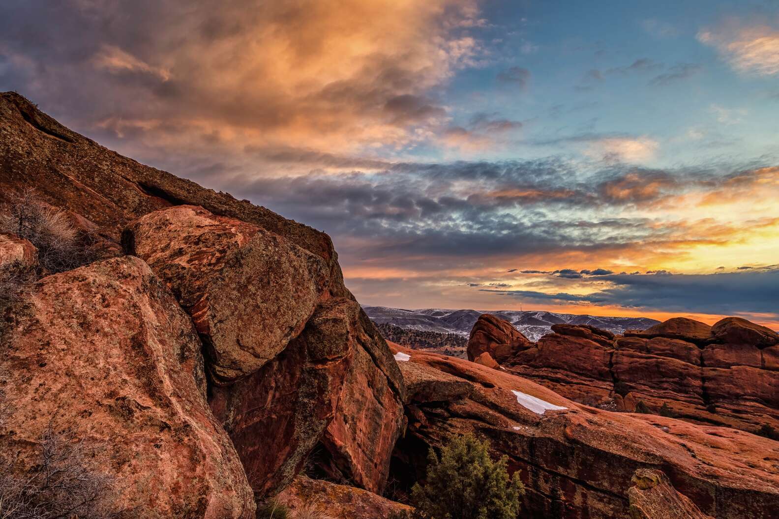
While destinations farther west get a lot of attention, the foothills near Denver are packed with gems, and many of them are along this route. You could easily make a whole day trip out of this 40 mile loop that will bring you on through Golden, Morrison, Kittredge, and Evergreen. Some must sees along the way: explore Red Rocks, take in the views of the Front Range on Lookout Mountain, and get up close with fossils on Dinosaur Ridge. There are also tons of hiking trails along the way—for a quick and satisfying break from the car, check out the Panorama Point Trail in Corwina Park near Kittredge. The 2.4 mile round trip takes about an hour and offers some seriously stunning mountain views when you reach the top.
Golden Gate Canyon and Arapaho Forest Scenic Drive
Distance from Denver: 30 minutes
If you’re looking for a leisurely drive on a paved road that doesn’t see much traffic—and is an alternate route from the Denver metro area into and past the Foothills—this drive will wind for just under 18 miles and into Golden Gate Canyon State Park. You can take it right up to Colorado Highway 119, which then directs either north to Nederland or south to Black Hawk. Or, loop around via Robinson Hill Road for a different perspective on your way back to Golden.
South Elk Creek Road
Distance from Denver: 40 minutes
This unassuming turn off of 285 near Conifer and Bailey is the kind of road you could drive by hundreds of times without noticing. But then you’d be missing out on a twisty adventure through acres of trees, passing by the cabin that once held the iconic Bucksnort Saloon. Though the Bucksnort is, sadly, no longer in operation, just beyond it at the end of South Elk Creek is the small town of Pine. Take a right to get to Pine Valley Ranch Park, the perfect place to stretch your legs while hiking Buck Gulch Trail or spend some time fishing (or ice skating) on Pine Lake.
Guanella Pass
Distance from Denver: 1 hour
Just shy of an hour’s drive from Denver, Guanella pass is a well-known name when it comes to steep, mountainous shortcuts with hairpin turns. It’s not a surprise this road is seasonal, closing once the cold weather arrives, but as far as I-70 alternates go, it’s definitely a looker. Plus, you can stop to fuel up at charming Idaho Springs and Georgetown on the way down to Leadville and Twin Lakes, or vice versa. Once Memorial Day rolls around, the twisty shortcut will reopen for the season, and checking out yellow aspens from here in the fall is well worth the trek.
Distance from Denver: 1 hour
This scenic byway doesn’t just offer incredible mountain vistas and adrenaline-fueling curves and climbs—it’s also the highest paved road in North America. Running 49 miles, the byway climbs more than 7,000 feet in elevation within 28 miles, reaching a peak altitude of 14,130 feet. Once at the top, you can take in the views of the entire Front Range and even catch a glimpse of marmots, mountain goats, and bighorn sheep among the rock cliffs and Colorado flora. The drive takes about two hours, with downtown Idaho Springs conveniently located on your way back to urban life if you need a post-drive snack. While the route is open year-round, be warned that weather can get dicey toward the summit. Visitors can also dive into the adventure that awaits within the Mount Blue Sky Wilderness Area and enjoy the recent road extension connecting Echo Lake to Bergen Park.
Distance from Denver: 1 hour
Colorado’s oldest scenic byway, this route from Black Hawk north to Estes Park was established in 1918. The 55 miles of roadway winds through classic Rocky Mountain scenery and there are tons of gravel road pull-offs along the way that lead to campgrounds, trailheads, lakes, and even a couple ghost towns (Hesse and Apex) making this a great route if you’ve got some extra time to explore. You’ll also go through the quirky town of Nederland, which isn’t known for ghosts but rather a cryogenically frozen dead guy.
Distance from Denver: 1 hour 15 minutes
Also open year-round is the Cache la Poudre North Park Scenic Byway, accessible from Fort Collins. The 101 mile-route typically takes around three hours to complete and is open all year, with the standard weather warnings of all Colorado scenic roads that are open year-round. The byway connects the college town of Fort Collins with North Park’s Walden, running through the Cache la Poudre River canyon (once used as a transit corridor for Native Americans) and along the white rushing waters of the river. At 10,276 feet is Cameron Pass, where the highway intersects Colorado State Forest—chances of seeing wildlife like elk, moose, beaver, and coyotes among this alpine environment are high.
Distance from Denver: 1 hour 20 minutes
This scenic byway that rarely dips below 9,000 feet in elevation spans all the way to Aspen, but you can start your journey closer. The best route from Denver is to start at Copper Mountain. From there, you’ll head south on 91 over Fremont Pass with views of the 14,265 foot Quandary Peak in the distance. A bit further south, you’ll hit Leadville, the highest incorporated community in the country and home to Turquoise Lake, a favorite spot for fishing, boating, and camping. The byway is 75 miles in total, and if you opt to drive the entire route, you’ll cross the Continental Divide twice and see stunning views of six of the state’s 14ers.

Loveland Pass
Distance from Denver: 1 hour 30 minutes
This pass essentially connects Loveland Ski Area and Arapahoe Basin, and is the highest mountain pass in the state that stays open during the winter season, sitting at 11,990 feet in elevation. The road isn’t for the faint of heart, with a consistent 6.7% grade and hairpin turns for almost the whole way, but views of nearby mountain peaks, access to Mt. Sniktau trailheads, and even a few picturesque alpine lakes make the journey worth it.

Distance from Denver: 1 hour 30 minutes
You can summit one of the state’s most iconic 14ers on this roadway. Pikes Peak near Colorado Springs is literally the place that inspired the lyric “purple mountain majesties” in “America the Beautiful,” and yes, it really is pretty damn majestic. You do have to pay a fee to access the road ($10 per adult or $35 for a car with up to five people), but with the Summit Visitors Center open, there’s plenty of parking and ample opportunity to get out and stretch before driving back down. Round trip, the trek typically takes two to four hours, depending on how long you want to spend exploring the pull-offs and taking in the views from the top. The road is open all year but does close as needed, depending on weather.

Skyline Drive
Distance from Denver: 2 hours
Yes, it’s a bit of a haul to get to this roadway in Cañon City from Denver, but it’s worth it for the thrill. Skyline Drive is a narrow, one-way road that’s 2.6 miles long and runs along the top of a razorback ridge. It’s basically a straight drop on either side, so you’ll definitely want to take it slow and stop to enjoy the views of the landscape below. The drive won’t take long, so you should also work in a stop at the nearby Royal Gorge, where you can walk across the highest suspension bridge in America (yes, you should probably avoid this whole adventure if you’ve got a fear of heights)

Distance from Denver: 2 hours
Get a glimpse into the state’s mining past on this route that spans 131 total miles and tours former gold camps in Southern Colorado including Cripple Creek, Florence, McCourt, Adelaide, Wilbur, and Victor. The byway is made up of four roads, and each offers a unique view of the land. While High Park Road and Teller County Road 1 are entirely paved, Phantom Canyon Road and Shelf road are more rugged legs of the adventure -- four wheel drive is recommended, as is the ability to keep your eyes on the road as you drive along a canyon wall 200 feet above a stream bed below. Along with plenty of chances to learn more about Colorado’s mining history, you’ll also see some of the state’s most beautiful areas including Fourmile Canyon, the Beaver Creek Wilderness Study Area, and the Garden Park Dinosaur Fossil Area.