8 Epic Long Hikes Around the World
The average person walks 275,000 miles in a lifetime—might as well make some of those steps epic.
The roaming gene is pretty darn strong in humans. Out of all the attractions I've tried in 150 countries, no travel activity is better than wandering. Like food and people-watching, strolling is a universal pastime. But instead of “watching the world go by,” you get to see more of the world as you cruise by. Without even getting too much into connecting with nature, with yourself, and all the wellness benefits, we can simply say taking long walks in a new place is next-level, state-of-mind stuff. No matter how you look at it, resolute rambling has been a low-cost human amusement for millions of years.
Many countries around the world have long trails that stretch for miles across the land. That means you can go as far or short a distance as you want; the length gives you plenty of options and so much of a country to see. It’s true some people walk 20 miles per day for months. That doesn’t have to be you. Maybe you only want to do a couple miles on two or even just one day of your travels. What’s important is that you can get a taste of each country’s flavor by embarking even for a short time across ancient roads.
These long-and-winding strolls around the world are not necessarily each country’s most famed, but they’ll deliver you straight into the heart and soul of a destination. Some charted, others invented on-the spot, these wild walks endure as the best way to merge choice with chance. Here are the top long walks around the world that define a country, help you understand what makes their culture tick, and allow you to roam out of bounds.

Trek with the oldest civilization on the Wukalina Walk
Tasmania, Australia
About 150-miles south of the Australian mainland lies an Ireland-sized island paradise where people don't honk or litter. In Tasmania, the palawa people have traversed a long-distance odyssey for centuries. The wukalina walk happens under Down Under, and is still owned and operated by the Aboriginal people whose ancestors invented the walkabout. The ancient trek—part bush, part beach—is a journey of rediscovery from the ashes of a genocide.
Early on, you’ll engage in an ancient pre-hunting ceremony initiated by painting your hands with wet, reddish clay to represent how the palawa camouflaged their entire bodies. Following Tasmanian Devil tracks, the crusade encounters wombats, wallabies, and kangaroos. The four-day journey is guided by tribe members (of Australia’s Stolen Generations), celebrating and striding in the footsteps of their ancestors. The hike is also peppered with stories of revered mutton birds, smoke-signal communication, and crayfish trapping. You'll also get to taste “bush tucker,” which is Aboriginal food and drink inspired by nature, including tasty tea made from the bark of a banksia tree. Meals include home-cooked beetroot, baked wallaby, and an ancestral delicacy of barbequed mutton bird.
Some Australians call this beach walk the Bay of Fires, a seemingly endless stretch of pure-white silky beaches, rocky headlands, and offshore rocks cropping up from blue water—all glowing in a multihued orange color energized by lichen. The trek is stretched over four days and covers about 22 miles with a couple hours each day. Your overnight digs along the Tasman Sea includes a “standing camp” (as in it’s movable if Mother Nature complains) with a wooden deck supporting a half-dome bandshell. It also comes with comfy chairs and mini couches that behold a magnetizing fire pit.
The trek’s finale is spent in a Lighthouse Keeper’s Cottage, a large multi-room granite house overlooking a lawn teeming with wallabies. Talk about a day at the beach. Experience a deep cultural immersion with the oldest surviving culture on earth.

Wander idyllic countrysides in The Boondocks
Luzon, Philippines
It might seem strange that the island of Luzon hosts both the capital city of Manila, home to 15 million people, and also the country’s most rugged and least populated region, known as the Philippine boondocks. There you’ll find a mountainous, rice-terraced cloud forest called the Cordillera. Visiting this cooler northern part of the country is like wandering through 11th-century harmony—the secluded mountain-range is still unscathed by roads, electricity, or other people’s gods. Boondocks, or boonies, are terms derived from a native Filipino word meaning “out in the woods,” since their word for mountain is bundok. The US military imported the slang to America in the early 1900s.
A path roams between valley villages in these boondocks, where walkers trudge up ridges and then descend into a rainforest. It can take around two to three days to see all the villages. Some inclines would be rated triple-diamond by extreme skiers, yet they’ve been conveniently sculpted for thousands of years into manageable passageways to maximize rice harvesting on land that’s anything but flat. The best way to stay on the right trail is tailing school kids, or locals transporting animals to adjoining villages or carrying babies on their backs. In other words, the trail connecting the different villages is highly used.
The trek’s starts at Batad, a magnificent village that’s a triumph of ancient community planning, where the rice-terrace irrigation technology created two thousand years ago still works today. An incredible labyrinth of mountainside canals flows from rivers and waterfalls into outlying crops. The effect is a valley paradise encircled by an amphitheater of rice-paddy terraces rimmed by stone walls, looking like enormous steps into steep mountainsides. The scene is colored by rice planters wearing wide-brimmed, grass sun hats and water buffalos pulling plows—all-purpose 4x4s that venture anywhere.
Rambling upstream, the next village is Cambulo, where many of its 1,300 residents will offer to take you in for the night for an incredibly modest fee. Continuously gaining elevation, the next village is hillside-hugging Pula, home to a two-room schoolhouse. From Pula, you hike high up into another climatic zone where conifer pine trees abruptly overtake the rainforest. The trail nears the base of the looming, 9,000-foot Mount Amuyao, covered in fog. The last town is Barlig, at which point you’ll return to Batad.

Cross a country on the Coast-to-Coast Walk
England
Northern England is an awesome testimonial to nature's might, a zone where heaven and earth appear to have been reversed. On the coast to coast hike, you can walk east-west across the width of England, end-to-end, and commune with nature, passionate gardeners, all-day dog walkers, and villages forgotten by modern highways and high-speed trains. Choose any section—or the whole shebang!—of a two-week 220-mile trek (eastbound recommended) from St. Bees on the Irish Sea to Robin Hood’s Bay on the North Sea.
The best guide for this journey will be the late Alfred Wainwright’s map and guidebook. Wainwright, known for his eccentric and solitary nature, became celebrated for linking the local footpaths, neighborhood shortcuts, and rural trails to craft splendid, extended hikes. The “Wainright Walk” meanders about 60 miles south of the Scottish border, an odyssey uniting a sequence of out-of-the-way gems that traverse three of England’s finest National Parks: Lake District, Yorkshire Dales, and North York Moors.
One of many outfitters can plan this for you A to Z, or semi-do-it-yourselfers can hunt their own enroute B&Bs while arranging with a transport service to convey their packs to drop-off points in the destination village upon each day’s walk. After hiking between eight and 20 miles a day, you can dine in cozy pubs. It’s rugged terrain trekking by day, bohemian elegance at night.
Tradition insists that you dip your toe into the Irish Sea to start the journey and into the North Sea to conclude it. The hike along a spectacular ridge within the Lake District gives you 360-degree views of mountains, lakes, and a final glimpse of the Irish Sea. You’ll encounter wildflowers, towering shoreline cliffs, dense forests, endless stone walls, forbidding mountain ranges, and ancient rail tunnels. The trek is like a frozen version of 1680—a literal outdoor museum with natural pieces of art.

Take in the highest heights on the Annapurna Base Camp Trek
Nepal
Eight of the world’s 10 highest mountains are in Nepal. The breathtaking Annapurna Sanctuary is a sky-high, oval-shaped glacial basin that sits in the cradle of the mind-blowing Annapurna mountain range, where most peaks tower more than 23,000 feet. The 13,000-foot plateau is a grand amphitheater ringed by mammoth granite mountains. It has one tapered entrance, a narrow valley between peaks, one of which is the nearly-five-miles-high Machapuchare, which cannot be climbed because it’s deemed sacred by the dominant Hindu populace. No foreigner even saw the Sanctuary until 1956.
The Annapurna Sanctuary trek is accessed via the small and really cool city of Pokhara. Depending upon how much you take advantage of towns along the way, you’ll be trekking for four to eight hours a day for more than a week, around eight to 10 days crossing 70 miles. You can book via an outfitter or on-the-spot in Kathmandu or Pokhara, where you also have the option of simply hiring a porter/guide, usually sherpas, who have high blood oxygen levels.
As you ascend, you’ll stay in increasingly rustic bohemian hotels or basic tea houses, where hikers dine and sleep on floors. The trek goes through an extraordinary medley of ecosystems, from south-facing slopes covered in dense tropical jungles of rhododendron and bamboo to north-facing slopes which have a drier, colder Tibetan Plateau-like climate.
It’s highly recommended that you start uphill training for any Nepal trek at least three months prior to stepping off the plane in Kathmandu, where a haircut sets you back $4 and includes a merciless head and back massage/beating along with a swerve into neck and back cracks. Also, don’t miss out on Nepalese momos. Order 10 gourmet buffalo momos soaked in cheese coriander sauce for a buck, and you’ll be hooked.

Feel like a Viking in Gros Morne National Park
Newfoundland, Canada
Simply knowing that Canada, Earth’s second largest country, is comprised of 10 provinces wins you respect points. One of those stars is Newfoundland, a spectacular 43,000-square-mile island of mountains meeting sea that’s the oldest part of the New World. The Vikings came here in the year 100, lasted 10 years, and left. Today, Newfoundlanders rise above isolation and long winters, showing you a warmth that’s particularly prominent, even for Canadians. Newfies have their own way of doing things and their own time zone: 1.5 hours earlier than EST.
Front and center is a multi-day trek spanning about four days in western Newfoundland’s ultra-wild, sub-arctic Gros Morne National Park. Gros Morne translates from French to “large mountain standing alone.” This is another planet; a nice planet. There is physical challenge involved in ascending above the treeline, but that effort is muted once you see the sights. As you rise above an ancient volcanic coastline, you’ll roam through a vivid mountain-plateau landscape full of deep glacier-carved fjords, lush valleys, tumbling waterfalls, abundant streams and ponds, and Arctic-alpine barrens. Woodland caribou, moose, grouse-like birds called rock ptarmigan, Arctic hare, black bear, and Arctic plants thrive in this UNESCO World Heritage wilderness. In fact, any well-worn trail was tromped by caribou.
You might feel like a Viking hiking through these worn, green-velvet-covered mountains, and you might even want to don Northern lingerie: an anti-bug net resembling a screened-in porch around your head. There will likely be gators, too: lower leg goulashes that resemble ankle-and-calf raincoats. Newfoundlanders have no word for goodbye, and you’ll want to get rid of yours too once you see this landscape you won’t want to leave.

Walk on the Caribbean’s wild side
St. Barts
Visiting St. Barts is a lesson in surviving extravagance. The eight-mile-long, volcanic, French-Caribbean island is certainly no bargain (cabs cost five bucks a minute), but there is free fun to be had in the form of off-trail hiking.
A two-hour hike stretches about two miles across the rocky and dry interior of the island and past many of its 22 beaches—all public—that are interspersed with craggy cliffs. The trail is not officially sanctioned and therefore involves a bit of trailblazing. The walk starts off with a two-hour bushwhack from Pointe a Toiny to Saline Beach on a pseudo-trail: i.e. a path that’s a little hard to make out. The trail first passes the Washing Machine, a cliff-encircled surfers’ beach (that’s not recommended for amateurs). Then, the path peters out into an arid ridgeline where navigating through cactus colonies and barbed brush startles packs of wild goats.
An hour later, Saline Beach, one of the island’s nude options, comes into view from afar. But before the relaxing part of the holiday can begin again, there’s still one more goat valley to navigate. In the guts of that final basin, you’ll find yourself under some shady trees behind a small cove. Once you walk over the final cliff, you can finally partake in a celebratory victory that includes splashing in water and cold beverages.

Follow history and magical gardens along Offa’s Dyke
Wales
This 180‑mile trek across Wales meanders coast‑to‑coast along Offa's Dyke, the grand dirt wall conceived in the 8th century by King Offa of Mercia to separate England from Wales. The immense earthen barrier, intended to keep the Welsh out of England, eventually became the border between England and Wales. On average, the dyke is 15-feet high and 20 foot wide. Often, you actually hike atop it. It passes through eight different counties and crosses the border between England and Wales 20 times. Acorn signposts and emblems clearly mark the entire way.
Offa’s Dyke links the two small coastal towns of Sedbury Cliffs and Prestatyn over the course of about two week, and it skirts the boundary of Brecon Beacons National Park, following along the top of a long, curving ridge and looking down on valleys below. It’s a meandering odyssey linking local footpaths, neighborhood shortcuts, and rural trails—all within miles of the dyke. You’ll roam along sheep trials, country roads, towering shoreline cliffs, across high plains, through dense forests, over naked peaks, across farmland, past gardens, along creeks and lakelands, under disused rail tunnels, and occasionally into the midst of grazing cattle. You’ll pass nearby Mount Snowdon, Britain’s second highest peak, which you can scale by foot or rail.
There are various services that will transport your luggage from town to town. Upon arriving in villages at night, locals will point you to a B&B, or you can book ahead at an amazing array of options including farmhouses, country inns, and luxury hotels. In smaller villages, you’ll find homes with names that tend to stay the same through perpetuity. In the Welsh-speaking parts of Wales, you’ll hopefully hear the nation’s ancient dialect that is Europe’s oldest living language, and is still a requirement for employment and other social blessings. Wales is a magical garden, making this a mythical journey. Hike the Dyke!

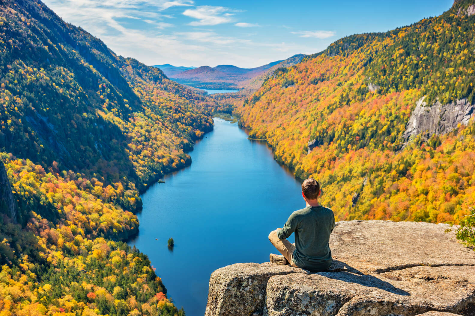
Work on becoming an Adirondack 46er
New York, USA
The Adirondacks are full of so many spectacular hikes that a local nickname has emerged from the region. An Adirondack 46er is someone who has summited all 46 of the high peaks of the Adirondack Mountains. Forty-two of these peaks rise above 4,000 feet, with Mount Marcy topping out at 5,344-feet and spawning the source of the Hudson River, Lake Tear of the Clouds.
Declared “Forever Wild,” the no-fee Adirondack Park in northeastern New York State covers 6.1 million acres—that’s bigger than Vermont—and is the largest single protected region found in the Lower 48. Polished by the last ice age, these five-million-year-old mountains are made of rock that’s more than 1,000-million years old. Unlike other famous US ranges that can be bone dry, this piney lair is home to thousands of lakes and ponds, 30,000 miles of rivers and streams, and countless swamps and marshes. Wildlife remains in charge here. The Mohawk and Algonquin tribes were the first to occupy this area. During a famine, the Algonquin resorted to eating tree bark, which moved the Mohawks to label them “Haderondah,” meaning tree-bark eaters. White colonizers later mispronounced it as Adirondack.
Like many hikers who conquer the Appalachian Trail in bits and pieces seasonally, this is not a classic thru hike. However, these peaks are intimate neighbors, which invites hikers to tack multiple trails into a longer excursion. Being a 46er also means conscious environmental stewardship. You can hear about the background and more at the Adirondack Experience at the Museum on Blue Mountain Lake.